Prestigio GEOVISION 4700: Autorouting
Autorouting: Prestigio GEOVISION 4700
EN-18
Autorouting
EN
Autorouting
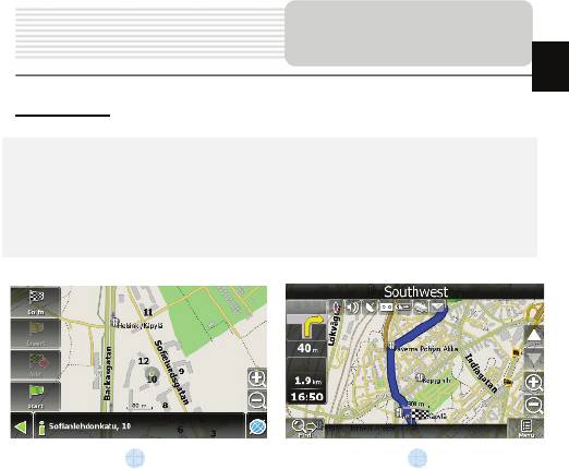
In order to create a route automatically, from the current position to the destination
point, tap with the stylus pen on the place on the map where the final point is, tap on
the “Cursor” button and in the context menu choose "Go to" (Fig. 1). The calculated
route will be shown on the map in blue color with highly visible dark border (Fig. 2).
Please, note that in case of non-routable maps, the route will represent a straight green
line from your position to the destination point, ignoring the existing buildings, roads, etc.
1 2
Оглавление
- Инструкции по
- Аксессуары
- Обзор устройства
- Обзор устройства
- Питание
- Начало работы
- Функция Bluetooth
- Соединение Bluetooth
- Функция Hands Free
- Hands Free Function
- Автороутинг
- Автороутинг
- Дополнительно
- Решение проблем
- Соединение с ПК
- Important Safety
- Accessories
- View of Main Unit
- View of Main Unit
- Device Connections
- Device Connections
- Cautions on Battery
- Getting Started
- Bluetooth Function
- Bluetooth Connection
- Hands Free Function
- Hands Free Function
- FM Function
- Program interface
- Program interface
- Program interface
- Program interface
- Autorouting
- Autorouting
- Additional features
- Troubleshooting
- Troubleshooting
- Technical specifications
- PC Connection
Топ 10 инструкций
100.00
MB QUART DSG 21399.98
Skil 0790 RA99.98
Bosch KGN39VW2199.97
Sony CDX-CA750X RU99.97
Braun 310 Series 399.96
Asus P3-PE599.96
Siemens MQ 5 N 29899.96
YUKON EXTEND LRS-1000


