Prestigio GeoVision 5050 Navitel: Autorouting
Autorouting: Prestigio GeoVision 5050 Navitel
EN-14
Autorouting
EN
Autorouting
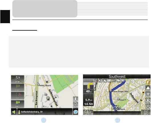
In order to create a route automatically, from the current position to the destination
point, tap with the stylus pen on the place on the map where the final point is, tap on
the “Cursor” button and in the context menu choose "Go to" (Fig. 1). The calculated
route will be shown on the map in blue color with highly visible dark border (Fig. 2).
Please, note that in case of non-routable maps, the route will represent a straight green
line from your position to the destination point, ignoring the existing buildings, roads, etc.
1 2
EN-15
Autorouting
EN
Autorouting using search
Find an object of interest using “Search” and press it with stylus, then select “Go To”
item from the menu. Apart from this item there are also “Insert” — add a point
between two points of existing route, and “Add” — point is added to the end of a
route and continues it. Both items are available only with existing route.
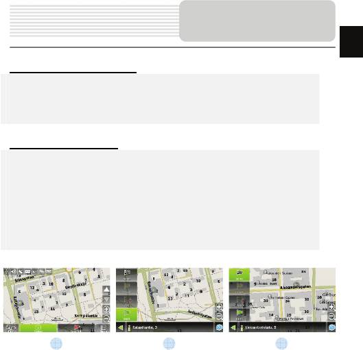
Manual route creation
The difference of this route creation method from previous two is what you can set a
start point and a destination point.
To create a route, press a map using stylus, press the “Cursor” (Fig. 1) button and
“Start” button after the menu appears (Fig. 2). Then find the destination point and
press “Cursor” — “Go To” (Fig. 3). If you using maps supports autorouting, route will
be created referring to this data and will be the shortest or the quickest. Otherwise
waypoints will be connected with strait green lines.
Please note! If GPS-receiver is active, you cannot set the start point!
1 2 3
Оглавление
- Инструкции по
- Аксессуары
- Обзор устройства
- Обзор устройства
- Системные
- Системные
- Питание
- Установка
- Начало работы
- Интерфейс п
- Интерфейс
- Интерфейс п
- Интерфейс
- Интерфейс п
- Автороутинг
- Автороутинг
- Дополнительно
- Решение проблем
- Решение проблем
- Соединение с ПК
- І
- Список аксесуарів
- Огляд пристрою
- Огляд пристрою
- Живлення пристрою
- Встановлення
- Початок роботи
- Інтерфейс п
- Інтерфейс програми
- Інтерфейс програми
- Інтерфейс програми
- Інтерфейс програми
- Автороутінг
- Автороутінг
- Додатково
- Вирішення проблем
- Вирішення проблем
- З'єднання з ПК
- Important Safety
- Accessories
- View of Main Unit
- View of Main Unit
- Device Connections
- Cautions on Battery
- Using Mounting
- Getting Started
- Program interface
- Program interface
- Autorouting
- Additional features
- Troubleshooting
- Troubleshooting
- PC Connection


